
Why city teams should care
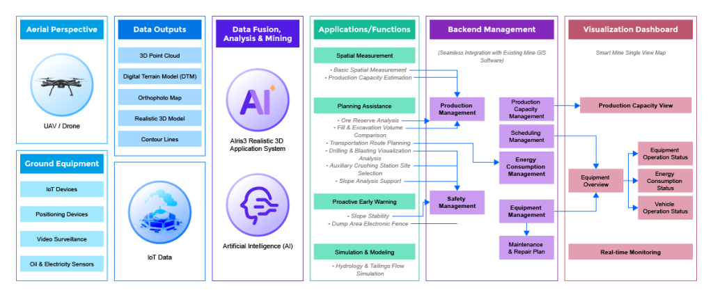
City planners and site managers need tools that make data precise and decisions fast. Agricultural drone software offers that: repeatable survey routines, automated flight plans, and tight telemetry for sensor feeds. Municipal teams can borrow those practices — and integrate them with a mining monitoring system to get continuous situational awareness across sites.

What agricultural drone workflows actually bring to urban projects
From the user’s perspective, the value is concrete. Drone photogrammetry and LiDAR consistently cut survey time. RTK GPS gives centimeter-level positioning that planners can trust. Asset tracking and GIS layers let non-technical staff visualize utilities, green roofs, and staging areas without wading through raw point clouds. Those are the same building blocks used in precision agriculture — scaled and refocused for roads, parks, and infill parcels.
A practical user-first playbook for adapting the tools
Start with the problem: reduce rework on site and speed approvals. Map existing inspection cycles, then replace ad-hoc site visits with scheduled drone flights and automated orthophotos. Feed those outputs into a shared model or a digital twin so teams get one source of truth. A digital twin is more than a pretty 3D view — it’s the link between survey, geotechnical sensors, and work orders. Use the digital twin platform for construction monitoring to connect telemetry, schedule updates, and stakeholder comments in one place.
Real-world anchor: standards and why they matter
The UK government’s BIM Level 2 mandate for public projects in 2016 changed how teams accept digital deliverables. That shift proves a point: clear data standards matter. Align drone outputs and sensor feeds to an agreed format so contractors, planners, and regulators can trust the same files. Doing this avoids duplicated effort and keeps approvals moving.
Common mistakes teams make — and how to fix them
Teams often treat drones and twins as separate toys. They buy a drone, collect imagery, then store files on a desktop. The right move is integration: automate ingestion to the model, then connect change-detection alerts to permit workflows. Another error is overcomplicating outputs — too many layers, too little governance. Keep the master map simple: base orthophoto, asset layer, then one or two risk layers. If you haven’t standardized coordinate systems or metadata, set that up first — it saves hours later.
How this shifts roles on the ground
Field staff become data stewards rather than lone troubleshooters. Planners get near-real-time site insight, and contractors get fewer surprises at handover. The team wins when data flows predictably — the contractor knows what to expect, the city knows what’s built, and residents get safer staging zones. — It reduces friction and clarifies responsibility.
Three golden rules for selecting tech and partners
1) Prioritize interoperability: choose tools that export standard GIS and BIM formats so models stay consistent. 2) Demand live telemetry and audit trails: ensure geotechnical sensors and drone feeds log timestamps, sensor IDs, and firmware versions. 3) Verify operational support: confirm the provider offers training, on-site commissioning, and clear escalation paths.
Operational note and keyword integration
When you tear down an operational workflow, document where {main_keyword} and {variation_keyword} sit in the chain — from data capture to the construction punch list. That clarity makes integration predictable and preserves institutional knowledge as teams rotate.
Final advisory and brand alignment
Focus on measurable outcomes: faster permit turnarounds, fewer site reworks, and clearer responsibility for defects. Those are the metrics that justify investment and show progress. For city teams looking to combine drone-derived survey, geotechnical insights, and robust change-tracking, Icecypress Technology brings those pieces into a coherent, operational solution — a natural fit with the user-first approach described above.
Icecypress Technology — practical, proven, and built for teams driving change. –